The browser will either open the file, download it, or display a dialog.
|
|
The Topographical Aesthetic in French Tourism and Landscape |
||||
| Introduction Nineteenth-century avant-garde art in Europe effected a general reversal in the academic hierarchy of pictorial genres, and with it came drastic changes in aesthetics and the nature of artistic meaning. As landscape, genre, and still life replaced history painting as the most valued subjects of art, painters and viewers placed increasing emphasis on empirical truth, individual sensation, and the indexing of authentic contemporary experience. The rise of landscape painting was, of course, central to this broad paradigm shift, and much has been written about the spread of open-air painting, the search for naturalism, and the bourgeois metropolitan market of Paris as key factors in the evolution of landscape painting in France.1 What I want to emphasize, by contrast, is the importance of French sites in the creation of new forms of aesthetic meaning. In France, the rise of the French landscape—the land itself—as a suitable subject in art engendered a distinctly new landscape aesthetic. It was not merely a local variation on naturalism but a distinct set of representational strategies carrying a new kind of landscape meaning, one tied ultimately to a particularly French form of national identity. This new aesthetic had roots in the particular viewing habits of French tourism within France. Analysis of French guidebook literature from the 1820s to the 1840s reveals the formation of what I am calling a "topographical" aesthetic characterized by a new, "self-reflexive" mode of cultural meaning. These topographical elements of the tourist discourse were also driving many of the artistic innovations of Camille Corot, Théodore Rousseau, Jules Dupré, and, ultimately, Gustave Courbet. The new aesthetic transformed naturalism, undermined the dominant aesthetic systems of the time (the Beautiful, the Sublime, and the Picturesque), and underlay, I believe, many subsequent developments of avant-garde practice. While a number of historians have discussed the general importance of tourism in altering landscape experience, my argument aims to be much more specific in positing similar, subtle strategies of meaning in both guidebook literature and painting.2 |
|||||
| Travel has always served as a material basis for landscape aesthetics in art: Claude Lorrain's sketches in Italy inspired his classical landscape manner, which inspired artists for centuries; Burke's concept of the Sublime was deeply associated with the sea and the Alps; Gilpin defined the Picturesque on the basis of walking tours of England; and excursions in Italy underlay the Neoclassicism of Valenciennes and his followers.3 Nineteenth-century artists, furthermore, had many professional reasons for traveling abroad: to train from ancient models, to see the paintings of Raphael or Rubens, to sketch distant lands for the print industry, or to learn English watercolor techniques. While such international communication bred stylistic and technical intermixing, specific geographical alterations (the suburbanization of Paris, English land enclosure, the mapping of the Americas, and so on) and evolution in the means of travel (ridding forests of bandits, opening railroads to the countryside, or cutting passes through the Alps) revolutionized people's perception of their worlds and opened new visual possibilities for the imagination. One can find germs of Turner's vortical motifs in his drawings of the Alps, for example, and the experiences of North Africa forever altered Delacroix's way of imagining his subjects. Travel, in short, was a form of artistic inspiration. On the other hand, these men were not unique creative explorers; they were people following group trends, and neither Turner nor Delacroix was a travel pioneer. | |||||
| When French painters in the circles of Théodore Rousseau and Camille Corot began to formulate new modes of landscape representation from the 1820s to the 1840s, they too were inspired by a specific kind of travel experience-travel through France. They joined a vast movement; after Napoleon's demise in 1815, modern tourism—a practice in which large numbers of people travel for pleasure or edification—exploded across Europe, giving rise to an increasingly sophisticated tourist industry. Most early guidebooks, however, focused on the three nations that represented, respectively, the three most valued aesthetic norms: Italy (the Beautiful, associated with classicism); Switzerland (the Sublime); and England (the Picturesque). Routes across the Alps and the Channel were, moreover, highly developed. The first carriage road over the Alps to Italy, via the Simplon Pass, had been built by Napoleon between 1800 and 1805, and an entire tourist infrastructure of roads, inns, and guides for hire made Switzerland a ready focus of travel.4 Tourism within France, in contrast, was not nearly as popular, and travel on French roads remained arduous and problematic through the 1840s, despite an elaborate national network of roads put in place before 1789.5 Amsterdam remained closer to Paris than the Pyrenees and more accessible than the Franche-Comté.6 So, in choosing to tour the provinces of France, artists and other travelers were following the new tourist industry, but they were also going against the grain by focusing on sites that were not canonized under prevailing aesthetics and not as accessible as France's neighbors. | |||||
|
To appreciate specifically how internal French tourism structured the new French landscape aesthetic, therefore, my argument is divided into three phases. The first sketches the general development of early tourism in Europe, focusing especially on French guidebooks for Switzerland and Italy. Turning to French guidebooks for France, the second section shows how domestic sites were interpreted differently from foreign ones. The final section analyzes the adoption of similar interpretive strategies in French paintings of French sites. |
|||||
| The Tourist Discourse Historians of tourism have shown that nineteenth-century tourism, like modern art, was a central practice in defining and enacting a dominant, upper-middle-class representation of modern life. Dean MacCannell's classic 1976 Marxist analysis of tourism remains indispensable.7It argues that, beginning in the nineteenth century, institutionalized tourism codified modern experience as a kind of spectacle of work. MacCannell sees travel to major monuments and cities to be a way of differentiating class by converting working-class labor into leisure for the middle class and thereby naturalizing social relations through a set of representations of sights and people. In the process, the tourist industry stages authenticity, making stereotypes seem real, overlaying actual people and places with signs that define them according to a middle-class vision of modern life. Ultimately, personal experience is itself highly mediated by such networks of false representations, making tourism an integral part of socializing individuals and legitimizing class. |
|||||
| Although MacCannell's analysis of modernity focuses on monuments, cities, and other work displays, it is relevant to landscape and natural sights as well.8 In general, what he describes as the commodification of cultural experiences is a key aspect of nineteenth-century guidebooks, which, we will see, packaged nature and history into a continuum called "culture." Equally relevant to guidebooks is his broad definition of the Picturesque as a modern mode of mapping actual experience according to preconceived signs of modernity.9 Furthermore, both the commodification of travel experience and the mapping of modern experience through representations are intimately bound up with the processes of producing modern art. Art and tourism have staged modern experience hand in hand. | |||||
|
A more recent analysis of British tourism by James Buzard extends some of MacCannell's points, especially in arguing that nineteenth-century tourism differentiated social groups ostensibly by personal character; the ability to select observed phenomena and compose them into a visual, picturesque whole distinguished true travelers from mere tourists, the former experiencing authentic culture and the latter simply reproducing the false representations scripted by guidebooks.10 Again, the underlying point is that tourism was a means of performing a class-based modernity, based on the consumption of cultural, rather than concrete, products. Other writers have viewed tourism similarly.11 |
|||||
| In the case of nineteenth-century France, Nicholas Green has shown how class-based modernity was enacted through what he terms "metropolitanism"-a new set of viewing habits elaborated in both art and tourism from the 1820s to 1850s. Landscape experience became a pivotal factor in a dialectical definition of class; for the urban bourgeoisie of Paris, "nature" was a foil against which its own modernity could be defined, and bourgeois identity was acted out through a particular mode of viewing and apprehending space.12 Green's work demonstrates how thoroughly art and tourism were intertwined in embodying social ideology. | |||||
| How exactly did the French guidebook industry prepare visitors to transform travel experience into cultural meaning? Before the gradual codification of the guidebook format following the Napoleonic era, the major forms of travel literature in France had included so-called vues (views), souvenirs (recollections), and voyages (journeys). Collections of prints with French titles such as Vues de . . . or Album pittoresque de . . . were frequently published in the late eighteenth and early nineteenth centuries. These prints tended to depict foreign cities, monuments, and landscape scenes in picturesque compositions emphasizing the monumental quality of representative sites. A set of views was, in a way, a set of fragments symbolizing different spectacles within a distant country.13 Souvenirs de voyages (sometimes entitled Notes d'un voyage . . .), on the other hand, were different, often written by professional writers and usually accompanied by only one or two images. Such books recounted actual journeys, presenting curiosities, spectacles, and historical information in an anecdotal style. | |||||
| The third term, voyages, was more general, embracing the many kinds of illustrated narratives between the two poles of views and recollections. Throughout the later eighteenth and early nineteenth centuries, the most common type of voyage was the expeditionary travel account, recounting journeys undertaken for more or less scientific purposes, such as studying mountains or ruins or exploring remote or unknown lands. Barbara Stafford has analyzed this genre of travel book in great detail, arguing that it represented a new, empirically grounded way of examining the world for the purpose of expanding natural history.14 Her examination of this new mode of vision is immensely revealing, but the diametrical opposition she poses between scientific and picturesque travel accounts was probably not always so clear in practice. The voyage pittoresque (picturesque journey), flourishing in the same period, overlapped the scientific travel account in many regards. Its title and format imply the vicarious touring of a specific land, with the aim of presenting illustrated highlights witnessed during an actual trip.15 The most famous example is Charles Nodier and Baron Taylor's long series of Voyages pittoresques et romantiques dans l'ancienne France, each publication of which was devoted to one region of France. It begins with Normandy in 1820–25, and the lavish, expensive folio volumes focus on medieval monuments, with highly romantic lithographs accompanied by long texts giving descriptive and historical information.16 Although the illustrations made it special, the series had a definite scientific, albeit romantic, intent as well and hints at the hybrid nature of travel literature that I see as determining the guidebook form. | |||||
| All these forms of travel accounts essentially provided the kind of worldly experience necessary to being a cultured person, presented in a form that had already transformed raw experience into culture. Consumers of these books may or may not have traveled themselves to the places described; the main point of the books was to turn travel into cultural knowledge. The genre of publication that became codified as the travel guide was fundamentally different in character. Its purpose was to instruct the reader in planning and executing his or her own actual trip to a specific land, facilitating one's own conversion of experience into culture, and it was designed to be portable, easy to update and republish, and distinctly affordable.17 These guides generally included a map; a section on handling money, hiring carriages, selecting inns, and so forth; a section on geography, geology, and the customs of the local people; and a series of lengthy itineraries describing possible routes and what to see along them. Routes had to be planned carefully to follow the complicated system of postal coaches and relay stations upon which middle-class tourists relied. Such guides usually were entitled Guide portatif, Guide pittoresque et portatif, Itinéraire, or sometimes Indicateur. | |||||
|
Probably the first famous example of such a book, and certainly the most influential one, was the Introduction to the Most Advantageous and Enjoyable Manner of Visiting Switzerland by Johann Gottfried Ebel (fig. 1), which the great English publisher Murray later claimed was the only guidebook worthy of its name for many years.18 Although the original version was four large volumes, it was slimmed down as it was constantly revised, republished, and translated to become a functional, portable guide. The French translation, Manuel du voyageur en Suisse, was published a second time in 1805 and frequently republished after that.19 France's greatest travel guide publisher, Richard (the pseudonym for Jean-Marie-Vincent Audin), published an edition in 1833 and again in 1834. French guides to Italy similarly increased at this time, the earliest usually based on English, Italian, and German guides; in 1825, for example, Langlois published in Paris a fifth edition of an Itinéraire classique de l'Italie based on travel accounts by various French and English writers. Richard's first Guide du voyageur en Italie, published in 1826, drew heavily upon an earlier guide by Giegler.20 Numerous other authors also published guides to Switzerland and Italy in the 1820s and 1830s, scattered among other forms of travel literature; the Bibliographie de la France lists on average four or five travel books per year published in French concerning Switzerland and more covering Italy.21 | ||||
| It was no accident that the evolution of the guidebook was tied so strongly to travel in Switzerland and Italy; these countries epitomized the traditional aesthetics of the Sublime and the Beautiful, respectively, while England, home to the Picturesque, was the third most common guidebook subject. In establishing the functions, strategies, and formats of subsequent guides, these early works naturalized specific modes of aesthetic interpretation as an inherent part of the tourist experience. For example, the fourth French edition of Ebel's Manuel du voyageur en Suisse, published in 1818 and by then a true guidebook, opens by extolling the ruins of ancient civilization as a foil for the greater, natural glories of the Alps. One must admit that "these works of nations that have disappeared . . . are effaced before the majestic ruins of the Earth. Now the chain of the Alps is nothing other than an enormous collection of ruins."22 After rhapsodizing about how the Alps witnessed the ancient seas and the creation of humans, the author asks: "What are the annals of humanity compared to the history of nature?"23 Other guidebooks similarly approach Switzerland as a marvel of natural history that highlights the limitations of human civilization. They invariably express admiration for the Swiss people, who maintained a rustic, pastoral life in a seemingly inhospitable environment, and express awe at human achievements in overcoming nature's barriers, such as tunnels, passes, and bridges. Human monuments, however, appear mainly as aesthetic objects accenting the main spectacle of nature narrated by the text. The textual shuttling back and forth between Alpine ruggedness and human cultivation was largely a reflection of the Swiss nation, which combined (and still combines) a natural sublimity with a highly developed social and agricultural system that in fact kept nature's dangers comfortably distant. One could climb to the Saint Bernard pass and stay in an inn, making a tour of Switzerland the perfect semiwild, semicivilized trip. | |||||
| In travel guides to Italy, on the other hand, cities, history, and art are the focus, with the land an essential backdrop to the display of cultural heritage. "There is surely no country where one can travel with as much pleasure and benefit as in Italy," writes Richard in the introduction to his 1826 Guide du voyageur en Italie.24 Besides the temperate climate, "it possesses a prodigious number of antique monuments which, in attesting to its former glory, fill us with admiration for the great men it has produced. One sees hardly a single place there that is not famous in history; not a mountain, not a river that has not been the theater for some memorable action."25 After praising the Italian language, literature, and music, he characterizes the country as a delicate concert of art and nature: "Such are the many and infinitely varied objects that nature and art have brought together as if by magic in Italy."26 For Italy as for Switzerland, most of the actual travel text of the guidebook consists of dry descriptions of every attraction that the traveler might pass, sequentially organized to mimic his or her linear movement. But whereas Swiss attractions were mainly natural sites, Italian ones were primarily buildings and sites of historical interest. | |||||
| These two guides establish two very different modes of landscape interpretation, rooted in the conventions of the Sublime and the Beautiful. Common to both, however, is the mixing of interpretative processes from both art and travel. Guides surely influenced the practice of professional and amateur artists, structuring their movements, suggesting motifs to sketch, and breaking the Sublime and the Beautiful into a succession of easily consumable glimpses.27 The artists, in turn, influenced the guides by coding sites with cultural meanings from classicism to Orientalism, advertising specific destinations through prints, and constituting a significant audience with special needs. | |||||
| More essential still is a fundamental goal that underlay both tourism and landscape representation: to convert the physical experience of moving through a sequence of prospects into a cultural experience, an experience that would enhance one's understanding of human life and human history while confirming one's own cultural ideologies. Both tourists and artists, in other words, sought to compose landscapes, converting "nature"—that sticky nineteenth-century abstraction—into culture. Before guidebooks, travel literature had effected this conversion for them, prepackaging nature in a cultural form that was reinforced by museum paintings. Guidebook travel, in contrast, promoted the tourist's own packaging of nature, buttressed by a flowering of amateur watercolor practice. Tourism and landscape were like twins, following similar developmental patterns and constantly intersecting. To generalize, every landscapist was part tourist and every tourist was part landscapist. | |||||
|
In rejecting travel to Italy and the Alps, then, the French artists in the circles of Rousseau and Corot were rejecting entire aesthetic systems. When they turned away from Italy's beautiful historical sites and Switzerland's sublime mountainscapes, they were instead exploring the less ideal, less mythologized internal landscape of France, seeking sites of "nature" that were old and cultured but inherently neither beautiful nor sublime. These artists were following the impulses and values of the new tourist discourse as it developed in Swiss and Italian tourism, but their travels and work corresponded more specifically to a particular, new branch of that discourse, French tourism within France itself. |
|||||
| The Mapping of France French travel guides for France did not mirror the lopsided preoccupation with natural grandeur found in guides for Switzerland or the rhetoric of classical heritage permeating Italian guides. The acculturation of nature in French guides was embraced within a more systemic interest in mapping out and describing the nation's historical geography. Combining history, geography, monuments, and aesthetic pleasure under one binding narrative, French guides presented France's "nature" as an inherent part of its nationhood. The focus was nearly always on historical sites and monuments but always with an assumption that history is geographically specific, that the peoples of France were part of the land where they lived, and that human physiognomy matched a certain landscape physiognomy. Individual regions of France were perceived both by their spokespeople and by the Parisian center as possessing individual cultures and ethnographic types that were embedded in the specific geography of the land.28 Traveling about France was thus part of a wide interest in mapping out the limits of the nation and its interior diversity of people, customs, economy, and landscape. One was exploring one's own nation and thus, to use Fernand Braudel's word, one's own identity.29 |
|||||
| This multifaceted character of landscape experience in France, encompassing aesthetic, historical, and typological interests, is apparent in the conglomeration of different kinds of literature in the guidebook form. Geographical literature, voyage and souvenir literature, and histories of regions were all common, mature genres of literature in France by 1830, and all were absorbed in the guides of the 1830s and 1840s while continuing to flourish independently. The exhaustive Bibliographie historique et topographique de la France, published in 1845 by the guidebook and geography writer Eusèbe Girault de Saint-Fargeau, conceives travel, geography, and the history of France's departments as inseparable. The book is divided into categories, including "Voyages en France," "Voyages en diverses provinces," "Guides portatifs," "Atlases," "Cartes," "Descriptions," "Dictionnaires," "Géographies," "Géologie," and "Histoire naturelle," as well as individual headings for each department. These categories are all assumed to be part of France's histoire and topographie. Further, all the kinds of travel literature discussed thus far appear in the sections on particular departments; some vues, voyages, souvenirs, and guides are listed under the headings "Voyages" or "Guides," but many others are listed under the department names. Thus the author found the distinction between, say, a geography of Auvergne and a travel guide for Auvergne to be slight, and his own prolific writings show that he felt himself to be contributing to all branches of history and topography, travel included.30 | |||||
|
These French guidebooks for travel in France, tied to this self-mapping tendency, developed and spread during the Restoration and July Monarchy, persisting as a full-blown industry from mid-century to the present day. An early series of guides based on travel routes by Régis-Jean-François Vaysse de Villiers was begun in 1813, with typically hybrid titles such as Itinéraire descriptif de la France: Géographie complète, historique et pittoresque.31 The most prolific and successful early guidebook publisher was Jean-Marie-Vincent Audin (1793-1851), cited earlier, who established a publishing house in Paris apparently in 1815 and also wrote some or all of his guides under the pseudonym "Richard." Richard originally may have been another person and is described in various guides as a former postal employee and engineer-geographer (ingénieur-géographe), perfectly apt professions for guidebook writing.32 Although Audin was known primarily for his histories of Luther, Calvin, Léon X, and Henri VIII, published between 1839 and 1847 and frequently republished, his first guide appears to have been the one to France, published in 1822 or 1823, and he went on to publish the previously cited guides to Switzerland (1824) and Italy (1826) as well as dozens of others on various countries and various regions of France into the 1850s.33 His single-volume Guide classique du voyageur en France seems to have been a standard, immensely successful manual; in 1826 he claimed that four editions of several thousand copies each had sold out in less than two years, with a fifth edition ready to appear, and the book was already in its fifteenth edition in 1832–33, its twenty-first in 1842. The twenty-eighth edition, of 1876, was published in a series by Joanne.34 |
|||||
|
What seems to be the first, still rough and unillustrated, edition of the Guide classique, probably published in 1823, sets the tone for later editions. It begins with a sixty-page introduction that explains money and postal routes, describes Paris and its environs, and gives advice on travel and health (among other things, do not take a room near a stable, sleep with the window closed, and carry a money belt). Without further introduction, it then jumps immediately into a dry recitation of sites, proceeding route by route until an unceremonious end on page 488, interspersed with occasional notes on the "Natural curiosities of the Department of X." The very first entry, on the road to Lyon, is typical:
This passage happens to highlight the topographical slant of the guide, but even beautiful natural curiosities, such as caves and cascades, are treated with a similar calculating objectivity, and the guide has far more information and statistics concerning land use, geography, demographics, and commerce than guidebooks for Switzerland or Italy and little historical information. |
|||||
|
One of the book's more enraptured descriptions is doubly significant because it reveals the limits of indulgence in rhetoric concerning the Sublime, the Beautiful, or the Picturesque and because it describes the Forest of Fontainebleau, which would become an important subject of French landscape painters and the focus of the artist colony at Barbizon in the 1830s.
This kind of "picturesque" description contains far less awe and drama than most guides to Switzerland, less even than Richard's own moderated discussions of the Alps. It is also a far cry from the delicately composed, classical views found in descriptions of Italy. Part of the reason for the difference is certainly the landscape itself—the Forest of Fontainebleau was genuinely different in character and form from Swiss and Italian sites—but the very presentation of the landscape is biased away from aesthetic pleasure toward topographical description. The end of the Fontainebleau entry reveals the abruptness with which the text can relapse from rapture back into objective measurement.
Later editions of Richard's guide become even more staid and topographical; the edition of 1832–33 eliminates the description of the Forest of Fontainebleau entirely, while the 1842 edition reinserts a much reduced version.38 |
|||||
| Even more closely bound up with geography is another complete manual for travel in France written by Girault de Saint-Fargeau (the author of the 1845 topographic bibliography) and entitled the Guide pittoresque, portatif et complet du voyageur en France. . . . It was probably first written in 1836, and a third edition was apparently published in both 1842 and 1850. The latter was published by Firmin Didot frères in Paris, and it claims that the first two editions were carried by "all travelers of fashion."39 Girault de Saint-Fargeau also wrote the comprehensive Dictionnaire géographique, historique, industriel et commerciel de toutes les communes de la France (Geographical, Historical, Industrial, and Commercial Dictionary of All the Communes of France), published by Firmin Didot in three volumes, 1844 to 1846. This dictionary, like others at the time, lists the location and population of every commune or town and most villages in France, giving lengthy descriptions of departments and larger towns, covering agriculture, industry, commerce, topography, geology, hydrology, customs, art, and so on. The difference between his guide and his dictionary is merely a shift in emphasis. | |||||
| Within the general development of the French guidebook industry, then, those guides pertaining to France itself show a marked difference from others in the way the landscape is interpreted. Where narratives about Switzerland and Italy emphasize the grandeur of nature and history, respectively, narratives about France are far more concerned with statistical and topographical description. Such description catalogues the geographical attributes of the nation, meticulously compiling an identity for each place and region. This kind of guidebook still acts like other guidebooks as a textual narrative converting travel experience into cultural knowledge, but the narrative is less visual and more topographical or indexical. The act of viewing the landscape is configured less as an act of aesthetic composition that gives a harmonious form to cultural ideas (nature and history, sublimity and beauty) and more as an act of physical surveillance that maps out the individual features and boundaries of France and its regional cultures.40 | |||||
| Such patterns of guidebook discourse suggest that internal French travel became in some sense a self-reflexive act, a way of cultivating and accruing private sensations and personal impressions that were linked together into a sense of national identity. The very act of moving about the landscape thus became meaningful—not just a catalyst for manufacturing cultural knowledge but a form of culture in itself. Unlike knowledge about the sublimity of "nature" or the greatness of human history, self-reflexive travel knowledge was essentially descriptive and contemporary, rooted in perception of the here and now and tied to the viewer's sense of his or her own position in the map of the nation. The land of France thus became the site of a new kind of cultural meaning, part of a pattern of representing the nation to itself as an object of modernity, a place where one found meaning in the process of exploring one's own sensations of contemporary reality. | |||||
| Topographical Painting In art, too, the French land became the basis for a new mode of cultural meaning, rooted in the same self-reflexive, topographical visual attitude. Switzerland remained the preeminent site of the Sublime, while Italy continued to generate new forms of classicim. As Peter Galassi has elegantly shown in his study of Corot's work in Rome, Italy represented everything art stood for—beauty, edifying nobility, and history.41 The reverence for Italy was especially strong in France, where Claude and Poussin had forever melded the cultural idea of classicism with the geography of Italy. Italianate classicism continued to hold sway over France's academic landscape tradition, and even Corot's brilliant empiricist innovations worked, as Galassi demonstrates, at the edges of the classical spectrum. As French artists began depicting France, however, they edged away from classical conventions, using non-beautiful, non-sublime types of land to forge new aesthetic principles carrying a distinctly new kind of cultural meaning. |
|||||
| Between the 1790s and the 1820s artists such as Lantara, Lazare Bruandet, and Georges Michel had concentrated on French sites but with modest results.42In the 1830s and 1840s especially, painters began to represent relatively obscure French sites with the same grandeur formerly reserved for narrative, classical landscapes. Their itineraries varied, but all made travel in France essential to their practice. Corot studied in Italy from 1825 to 1828, returned twice afterward, and painted narrative landscapes throughout his career, but he also depicted prosaic sites around France and settled at his family home in Ville d'Avray, just west of Paris near Sèvres. Louis Cabat, an influential member of both the Corot and the Rousseau camps, made the first of several visits to Italy in 1836–37 and 1838–39, but he also traveled extensively around France from the early 1830s on.43 Rousseau, one of the staunchest devotees of French sites, stayed in France except for two brief excursions into Switzerland, and after several trips all over France he settled in the village of Barbizon south of Paris, making the Forest of Fontainebleau his studio.44 Jules Dupré, Rousseau's friend and travel companion before 1848, traveled still more around France before settling in 1845 at l'Isle-Adam, north of Paris. He visited England in 1831 but not Italy.45 Rousseau's best friend after 1848 was Jean-François Millet, who grew up on the tip of Normandy and settled down the street from Rousseau at Barbizon, leaving France only late in life for trips to Switzerland.46 A third Barbizon painter, Narcisse Diaz, also remained in France except for possible trips to Spain and London and a trip to Brussels late in life.47 Other artists kept to their own special itineraries, with England attracting more attention than Italy.48 | |||||
| This new focus on the French land was not simply a rejection of Italianate classicism. All these artists revered Claude, who had spent his life in Rome. Further, Corot's first teacher, Achille Michallon, won the first Prix de Rome in historical landscape in 1817; Rousseau's first teacher, Jean-Charles-Joseph Rémond, won the next in 1821; and Corot himself never abandoned Italian motifs.49 Nor was the concentration on France a simple matter of embracing naturalism. If so, one might expect the French painters to have traveled to Holland, which offered a crucial alternate heritage to that of Italy. They did, after all, imitate seventeenth-century Dutch models, they praised Dutch masters, and critics routinely identified Dutch influences in their pictures. Théophile Thoré, the first major writer to revive Dutch art, was Rousseau's closest friend in the 1840s. Rousseau and Dupré were particularly inspired by Dutch naturalism and sought in France the same kind of planar topography so common in Dutch landscape.50 Nevertheless, only a few artists traveled to Holland, with few pictures to show for it.51 France clearly offered something new and special. | |||||
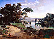
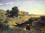
| Some indication of France's distinct aesthetic value is evident within Corot's work. His first Salon painting, the 1827 Bridge at Narni (fig. 2), uses the actual topography of the Italian site as a compositional basis for a Claudian, classically ordered visual reverie.52 On the other hand, Hagar in the Wilderness (fig. 3), shown at the Salon of 1835, incorporates a section of French land in the center to buttress the picture's main theme of being lost in a wasteland lacking history, beauty, and meaning.53 Both works are fabrications elaborated from plein-air studies, but they deploy different topographies to convey quite different types of meaning. | |||||
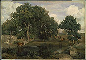
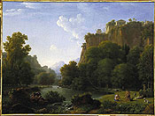
| In one of Corot's mature French landscapes, View in the Forest of Fontainebleau of 1846 (fig. 4), he again gives the invented scene a slightly more topographical emphasis than that of his major Italian landscapes. Far removed from the biblical and mythological scenes he was producing in the same period, this picture focuses on a blank banal space of pond, earth, and trees, colored in dusty earth tones and accented with a most prosaic subject of a shepherd and cows. A few Italian scenes are similar-his 1843 views of Genzano and Lake Nemi, for example-but these well-known sites near Rome retain classical associations absent from the French royal Forest of Fontainebleau. Corot also emphasizes this lack of history and culture at the Fontainebleau site, even while preserving a loosely Claudian compositional scheme. The less than gracious reaction from critics-one said Corot "paints everything with the dirt that falls from his boots"-underscores how unclassical viewers found both the motif and the style.54 | |||||
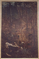
| Far more dramatic is the contrast between Jean-Joseph-Xavier Bidault's Historical Landscape with Psyche and Pan (fig. 5), shown at the Salon of 1819, and Théodore Rousseau's Descent of the Cows (fig. 6), rejected for the Salon of 1836.55 Bidault was the leading Neoclassical landscapist after Valenciennes, and his 1819 painting, while presuming to show ancient Greece, was based on his outdoor training in Italy. Rousseau was a fiery rising star who became a standard-bearer of the avant-garde by being systematically rejected from the Salons from 1834 to 1848. His Descent was based on an event he witnessed in the French Juras near Geneva. Bidault took the lead in persecuting Rousseau in the 1830s, and it is easy to see why. Rousseau's severely anticlassical narrative of cows descending from highland pastures was an intentional assault upon the mythical visions fabricated by Bidault and his academic associates. The Descent's blunt, cramped, dark, vertically oriented, and fir-covered precipice destroyed almost point by point the Italianate aesthetic that was so integral to the visual comprehension of classical narrative meaning. Noble reverie is impossible, with attention focused instead on the local character of the cows and herdsmen, the messy reality of the ephemeral moment, and the viewer's own physical presence on a slope in the woods. History gives way to genre, beauty to chaos. The picture's full title—The Descent of the Cows, in the Mountains of the High Jura—further emphasizes the banality of the action and the regional specificity of the site.56 Ironically, Rousseau went there intending to make a grand picture of the Alps seen across Lake Geneva. The fact that he chose instead this six-foot-tall scene to be his (failed) Salon machine highlights the degree to which he reconfigured previous expectations of what meaningful landscape experience entailed.57 | |||||
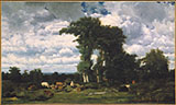
| As artists in Rousseau's circle matured during the 1830s, this new mode of landscape became more systematic and more clearly rooted in nonclassical, specifically French topography. Typical is an important painting of 1837 by Rousseau's friend Jules Dupré. With even less narrative content than The Descent, Dupré's Limousin Pastures (fig. 7) depicts a barren flat terrain breaking traditional aesthetic canons (even Dutch ones) and offering no historical or cultural theme.58 The title again underscores the local character of the scene and the meaninglessness of the site in French culture; the Limousin landscape was not famed for anything and was not featured in national guidebooks. Dupré's trees, logs, and cows are more clearly delineated than Rousseau's, suggesting that the scene is an accurate description of a perfectly banal fragment of the countryside. The blocking of the central space by the trees further disrupts any attempt to read reverie or awe into the picture, shifting the viewer's focus from the overall shape of a remote spectacle to the close examination of a chunk of actual, material land. Like the Descent, Dupré's work emphasizes physical sensation, suggesting what Claudia Einecke has called a "somatic" experience of the landscape.59 | |||||
|
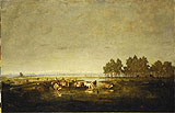
By the 1840s Rousseau and Dupré had fully supplanted the aesthetics of the Beautiful, Sublime, and Picturesque with new aesthetic formulas. I have argued at length elsewhere for understanding such formulas as embodying an ecological visual attitude,60 but it is sufficient here to point out how radically they altered both style and meaning. In Marsh in Les Landes of 1844–56, for example (fig. 8), Rousseau deployed the same flat ground, shadowed frame, and remote central motif that he was using regularly at the time. Again, the shepherd theme is prosaic, the home in the background is ordinary, and the site is free of history. All the elements highlight the unique local culture and topography of the region. Most significant, the Pyrenees mountains—at the time, one of France's most popular tourist destinations and commonly cited as the French counterpart to the Swiss Alps—are pushed far to the horizon, almost to invisibility. Rousseau consciously placed in the foreground precisely those features of the region that were considered devoid of aesthetic value, as made clear in this typical guidebook comment:
Other writers described the swamps and people alike as sickly, the lifestyle primitive beyond rustic. Rousseau was representing a site that was too ugly even for French guidebooks and a local culture considered unworthy of being seen in a manner that embraced qualities antithetical to classical aesthetic values. |
||||
| In planting their easels in the French countryside, then, Rousseau, Corot, and others in their orbit were not simply pursuing naturalism or plein-air spontaneity; they were transforming the very definition of art. Instead of composing ideal views of distant Italy in order to inspire the viewer to contemplate noble timeless thoughts, artists were now to index the real diversity of France in order to chart the contemporary rural cultures of the nation. No longer would a landscape of myth or history be more noble than a study of a tree or a stream; no longer would gods be more important than peasants or Roman shepherds more lyrical than French ones. The ordinary land of France became a worthy cultural base for the production of meaningful images, and these new types of images paralleled the visual attitudes constructed in French guidebooks. Taken as a set, the pictures compile fairly objective, unembellished, and close-up scenes of unremarkable fragments of French land into a catalogue of the nation's topographical parts. For both tourists and art viewers, prosaic topography became an attribute of the French nation, and one's presence before such land became a bond with France's contemporary culture. Surveying the nation's land became a unique new way of performing a national identity. | |||||
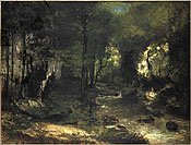
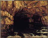
| The importance of this new aesthetic attitude extended beyond the landscapes of Corot and Rousseau, influencing the rise of Realism more generally. In the many landscapes Courbet painted around his hometown of Ornans in the 1850s and 1860s, the scenes are rigorously nonnarrative, with banal motifs and unorthodox compositions. He gave them emphatically local, cartographic titles, such as The Stream of the Puits-Noir, Valley of the Loue (Doubs) (fig. 9), while continuing to document the inhabitants of the area in his figure paintings.62 Throughout his career, he also trumpeted his own identification with these unknown sites and highly localized regional customs. More radical than his Barbizon predecessors, Courbet blasted all remnants of classical technique, troweling the paint onto the rocks and water of the Puits-Noir and suffocating the Beautiful under a coating of dense foliage, rock, and earth that leaves little room for poetic atmosphere or idealistic reverie. The unrelenting materiality of his Realist aesthetic is most triumphant in the Source of the Loue paintings (fig. 10).63 Their motif—the emergence of the Loue River from its cliffside spring near Ornans—is startling and gorgeous but not in the manner of Swiss or Italian sites. It is a geological and topographical wonder, one with no connection to history or culture. Courbet's mode of presentation staunchly expunges the distant viewpoint, foliated frame, Claudian pathways, and smooth modeling that could easily make the same site an object of picturesque beauty. The painting presumes to transcribe a purely natural site, whose cultural meaning lies wholly in its topographical peculiarity and its relationship to the geography of France. | |||||
| Such pictures opened new paths for interpreting art. Rooted in actual physical experience, they urge viewers to imagine their own bodily sensations at the depicted location. Focused on sites free of historical and discursive associations, they allow viewers to imagine their own unscripted responses to the scenes. Undermining the aesthetic formulas of old, they draw attention to the processes of representation. The topographical aesthetic, in short, came to place value on actual, ordinary, and self-consciously contemporary experience—hallmarks of subsequent avant—garde practice. Plein-air naturalism was but a small part of this development; far more profound was the rise of a new, self-reflexive way of constructing cultural meaning from lived experience. And in this new paradigm, France had become the privileged site of such cultural production. |
|||||
|
Unless otherwise indicated, translations are my own. 1. Important recent works on mid-nineteenth-century French landscape include Green 1990; Champa 1991; Adams 1994; John House, "Framing the Landscape," in House 1995, pp. 12-29; and Burmester, Heilmann, and Zimmermann 1999. 2. General links between nineteenth-century tourism and landscape are discussed in House 1995 and Dabrowski 1999. More thorough are the studies found in Herbert 1988 and Green 1990. 3. Burke's Philosophical Enquiry into the Origin of Our Ideas of the Sublime and the Beautiful was first published in 1757. Of Gilpin's many guides and art manuals, see especially Three Essays: On Picturesque Beauty; On Picturesque Travel; and On Sketching Landscape (London, 1792). On Valenciennes and Corot, see especially Galassi 1991. On interactions between art and travel in shaping the English Picturesque, see Andrews 1989. 4. The Simplon Pass road was one of the regular highlights of guides to both Switzerland and Italy. Richard (1824, pp. 97-98), for example, includes a lengthy description of the ascent of the pass in his first Swiss guide and devotes one of the eight illustrations in the book to the broad road, its guard wall, its hospice buildings, and its precipitous drop. In his Guide du voyageur en Italie (1826, pp. 145-46), he goes into still greater detail, lauding the breadth of the road and its railings, sidewalks, and shelters. He also remarks (p. 3) that whereas the Alps had formerly isolated Italy from the world, they were no longer a terror: "Today, majestic roads opened in the precipices of these mountains have destroyed the barriers given to Italy by nature" ("Aujourd'hui des routes majestueuses ouvertes dans les précipices de ces montagnes, ont détruit les barrières données à l'Italie par la nature"). 5. Grad and Riggs (1982, pp. 25-26) describe the bandits, disrepair, and general discomfort that plagued the French road system. Braudel discusses the general history of the French road and railroad system (1988-90, vol. 2, pp. 460-500), including the insufficiencies of the road system, particularly in the south (pp. 466-70). 6. Many editions of Richard's Guide classique du voyageur en France (see note 34 below) include a brief Guide en Belgique et Hollande, these two countries thus being configured as somewhat integral to France; the distance from Paris to Amsterdam is approximately 123 lieues (1 lieue equaling about 4 km), roughly the same as from Paris to Lyon (119 lieues) and much less than the 221 lieues from Paris to Bayonne. 7. MacCannell 1989. 8. In a passing mention of parks, MacCannell (ibid., pp. 80-82) notes that modernity has transformed nature from a locus of danger and passion into one of recreational pleasure. 9. MacCannell uses the term picturesque more broadly than historians of art and defines it only obliquely in his discussion of the "semiotic of attraction." Of a guidebook description of the view from the Eiffel Tower, for example, he writes: "What is interesting about this claim is its emphasis on the wonderful quality of seeing actual objects as if they are pictures, maps or panoramas of themselves" (ibid., p. 122). 10. See the introduction to Buzard 1993. The body of the text focuses on British accounts of travel to the Continent. 12. Green 1990. This urban/rural dialectic is also discussed in Grad and Riggs 1982. 13. Collecting these views was somewhat analogous to collecting specimens of natural history, such as rocks or insects, a more and more widespread practice in the late eighteenth and early nineteenth centuries. The views in this sense served a semiscientific purpose, even though they often were not highly descriptive. 14. Stafford 1984. See also the important review of her book in Rosen 1986. 15. For an overview of the genre and its practitioners, see Adhémar 1938. He shows that the roots of the voyage pittoresque tradition date back to the mid-eighteenth century, before Gilpin (1972, pp. 197-208) redefined the notion of the Picturesque. 16. Haute Normandie was published in two volumes (1820-25), Franche-Comté (Nodier's home region) was published in one volume (1825-29), Auvergne followed in two volumes (1829-33), and so on. The project employed a large number of writers and artists and generated a great deal of innovation in lithography. For information on this monumental series, see Spadafore 1973 and Grad and Riggs 1982, pp. 15-25. 17. In France, the price of a guidebook in the 1830s and 1840s ranged roughly from 3 to 12 francs, and the size was usually in-8° or in-12° and often smaller. Souvenirs and related publications had similar prices, but guidebooks had more pages, information, charts, and maps for the same price. Illustrated vues and voyages were considerably more expensive; in 1831, for example, Richard's Guide du voyageur en France cost 4 francs, while a book entitled Vues prises dans les Pyrénées françaises, published in six parts, cost 6 francs per part; a Vues des côtes de France, comprised of 15 issues, cost 12 francs per issues, and the Auvergne volume of Nodier and Taylor's Voyages pittoresques . . . cost 15 1/2 francs. 18. Murray 1839, p. v. The original German title was Anleitung, auf die nützlichste und genussvollste Art die Schweitz zu bereisen . . . (Ebel 1809-10); at least one earlier version of the book was published, which I have not found. 19. I do not know when the first French edition was published, though Ebel's Instructions pour un voyageur en Suisse was published in French in 1795. A fourth French edition, in one volume, was published in Paris by Langlois in 1818, and a ninth edition was published by Langlois's successor, Bastien, in 1835. An English edition of Ebel's work was published by Daniel Wall in London in 1818. 20. In his Guide du voyageur en Italie (Richard 1826, pp. v-vii), he reviews the existing guides to Italy and states that his own reprints almost entirely a Manuel du voyageur en Italie by Giegler published in Milan. Richard also states in an insert addressed to hotel owners (in the version at the Bibliothèque Nationale, Paris) that Giegler's book and another, an Itinéraire d'Italie published in France and Italy, are the two most esteemed guides to Italy. 21. This information is drawn from the Bibliographie de la France, an annual serial of new publications in France, and from examination of guidebooks in various libraries. 22. "Ces ouvrages des peuples qui ont disparus . . . s'anéantissent devant les ruines majestueuses de la Terre. Or, la chaîne des Alpes n'est autre chose qu'une énorme collection de ruines." Ebel 1818, p. 1. 23. "Que sont les annales de l'humanité comparées à l'histoire de la nature?" Ibid., p. 2. 24. "Il n'y a sûrement aucun pays où l'on puisse voyager avec autant de plaisir et d'utilité qu'en Italie." Richard 1826, p. 3. 25. "Elle possède une prodigieuse quantité de monuments antiques, qui, en attestant sa gloire passée, nous remplissent d'admiration pour les grands hommes qu'elle a produits. On n'y voit presque aucun endroit qui ne soit fameux dans l'histoire; pas une montagne, pas une rivière, qui n'ait été le théâtre de quelque action mémorable." Ibid. 26. "Tels sont les objets multipliés et infiniment variés que la nature et l'art ont réuni comme par enchantement en Italie." Ibid., p. 4. 27. Guidebooks frequently addressed professional and amateur artists directly, and artists and tourists certainly mixed a great deal; prints of artists sketching, for example, enjoyed a certain popularity and often showed them in a scenic location among tourists. It is also important to remember that although artists sometimes ventured off on their own to travel or sketch, they generally had to follow the same constraints placed on other tourists by the road system, use of public carriages, location of inns, and reliance on guidebook information. 28. See Weber 1976, chap. 1. The tension between national and local identity in landscape painting is also clearly presented in James F. McMillan, "La France Profonde, Modernity, and National Identity," in House 1995, pp. 52-59. 29. The interweaving of history with geography is the essential subject of Braudel 1988-90. 30. Beginning with his Dictionnaire de la géographie physique et politique de la France, published in 1826, Pierre-Augustin-Eusèbe Girault de Saint-Fargeau (born 1791) covered several genres with more than a dozen books, including Dictionnaire des artistes (1846), books on the geography of Paris and the 1830 revolution, and a number of detailed dictionaries of the communes of France. He also wrote the six-volume Guide pittoresque du voyageur en France (in-8°, with 700 illustrations, published 1833-36), as well as the single-volume Guide pittoresque, portatif et complet, du voyageur en France (in-12°, first published 1838). See the 1875 biographical notice excerpted from A. Dantes in Bradley 1988. 31. These guides extended to more than twenty volumes, divided by region and organized by route, with certain books republished through the 1830s. The title cited ("Descriptive Itinerary of France: A Complete Historical and Picturesque Dictionary") is from a volume on the south published by Renouard in 1835. 32. Although bibliographers have assumed Richard to be a pseudonym for Audin, it is likely that there originally was someone named Richard and that Audin kept using the name after Richard's death. The preface to the 1826 Italy guide states (p. vii) that Richard, who had authored the highly successful Guide en France, had left some notes on Italy before his death and that these notes were included in the Italy guide. The first edition of the French guide itself begins with travel advice "excerpted literally from Reichard" [sic] ("Observations . . . extraites littéralement de Reichard"). It is also difficult to see how one man could gather the expertise necessary both to create a monumental guide to France and to write religious histories. Concerning Audin's life and works, see the notices from F. X. de Feller (1851) and J. C. F. Hoefer (1852) in Bradley 1988. 33. These are the Guide du voyageur en Suisse (in-8°, first published in installments for 12 francs) and the Guide du voyageur en Italie (published in-12° or in-16° for 8 francs). 34. The Guide classique du voyageur en France was published in varying forms, most often including Belgium. In 1825 it was published in the format in-12°, and in other years in the very compact format in-16°. In 1826 it cost 7 1/2 francs, map included, and the price was the same in 1842. In several editions, Audin warns readers that imitators are publishing unauthorized versions of his guides and that the authentic versions are sold only at the Librairie Audin in Paris and other specified bookstores throughout France. The 1842 edition indicates that the new publisher of the Guide classique, Mr. Maison, is Mr. Audin's successor. The guide continued to be published by Hachette in altered form until 1896, and the twenty-eighth edition, of 1876, was published as part of the "Collection des Guides-Joanne," which became France's leading guidebook series in the later nineteenth century. All guidebook information is drawn from the catalogue of the Bibliothèque Nationale, the Bibliographie de la France, and individual guides. 35. "Villejuif (Seine). Petit bourg sur une hauteur, chef-lieu du canton, à une l. au S. de Paris, remarquable par un obélisque que l'on voit à son entrée; il marque l'extrémité septentrionale de la base d'un triangle qui a servi à mesurer un arc du méridien; l'extrémité de cette base est déterminée par un obélisque pareil, que l'on voit à Juvisy." Richard [1823], p. 61. 36. "L'étonnante variété des sites singuliers et pittoresques qu'elle offre au voyageur est vraiment remarquable: il voit çà et là des roches informes, noirâtres, carriées, couvertes de mousses et de lichens; des blocs énormes de grès irrégulièrement entassés, et figurant par leurs contours tronqués les formes les plus étranges; plus loin ce ne sont que des sables arides." Ibid., p. 62. 38. Richard 1832-33, pp. 248-49, 439-40; and Richard 1842, pp. 313-15. Descriptions of the Forest of Fontainebleau in other guides are comparable in attitude and tone to Richard's; see, for example, Anonymous 1835, pp. 10-14. 39. The full title of the third edition is Guide pittoresque, portatif et complet du voyageur en France, comprenant les relais de poste, dont la distance a été convertie en kilomètres. The Bibliographie de la France lists a third edition, of 1842, and the Bibliothèque Nationale has a third edition, of 1850. The 1850 book states (p. v) that two earlier editions, published under a pseudonym in five volumes in-8° and in 4,500 copies each, sold out in less than three years. It further claims that this book is found (despite its bulk) "dans les chaises de poste de tous les voyageurs fashionables." 41. Galassi 1991. 42. Concerning this early phase of French landscape painting, the best overall study remains Dorbec 1925. For a more concise treatment, see Rosenthal (1914) 1987, pp. 262-97, and Adams 1994. Some mention is also made in Herbert 1962, pp. 15-20. On Michel, see Sensier 1873 (which also contains some discussion of the enigmatic Bruandet). 43. On Cabat, see Miquel 1975-85, vol. 3, pp. 482ff. 44. In 1834, after staying in the French Juras for a few months, Rousseau spent a week or so climbing to the Saint-Bernard Pass. In 1860 he traveled with his wife and Millet to Morat, northwest of Fribourg. Concerning these trips, see Sensier 1872, pp. 59-73, 255-56. Sensier's is still the fullest study of Rousseau's life and work, but see also Miquel 1975-85, vol. 3, pp. 430-81, and Schulman 1997-99. 45. For information on Dupré's travels, see Miquel 1975-85, vol. 2, pp. 360-94. Miquel (p. 363) indicates a possible second trip, in 1833, while Herbert (1962, pp. 17, 46, states that Dupré visited England in 1834. 46. Millet traveled to Switzerland with Rousseau in 1860 (Sensier 1872, p. 255) and again on his own in 1868. His large family and meager finances precluded longer trips. 47. Diaz was also hampered by having a wooden leg. While in the Pyrenees in 1832 and 1833, he may have crossed into his native Spain (Miquel 1975-85, vol. 2, pp. 285-86) and may have visited London in 1835 (Paris 1968, n.p.). He visited Brussels and possibly London in 1871 (Miquel 1975-85, vol. 2, p. 315). 48. Géricault was an early model for visits to England, having stayed from April 1820 to December 1821. The wealth of broader artistic exchange between France and England after the Napoleonic era has also been well documented; see, for example, Pointon 1985. Delacroix is an especially telling example; he visited England in 1825 but never went to Italy, finding classical inspiration instead in the people and land of North Africa during his 1832 stay. 49. For the history of this competition, see Grunchec 1984-85. 50. Dupré and Rousseau specifically sought out the barren plains of the Berry and Landes regions of France in forging their mature styles. 51. Rousseau never traveled to Holland, but Corot went in 1854 and Huet went in 1864. 52. On Narni, see Tinterow, Pantazzi, and Pomarède 1996, pp. 73-78, and Galassi 1991, pp. 166-70. Galassi argues for the classical interpretation of the composition. 53. Although meant to represent the desert of Beersheba, in modern Israel, the central hill and trees are based on a study of the Forest of Fontainebleau. The background ridges are apparently based on studies in Italy (see Tinterow, Pantazzi, and Pomarède 1996, pp. 90-92, 154-57, and Galassi 1991, pp. 80-81). 55. The Bidault painting is reproduced and discussed in Galassi 1991, pp. 48-50. Concerning the Rousseau painting, see Marie-Thérèse de Forges in Toussaint 1967, no. 15. The version Rousseau exhibited is most likely the ruined one in the Mesdag Museum; the Amiens version reproduced here was painted as a duplicate. 56. The painting was exhibited and reviewed under various titles. La descente des vaches, dans les montagnes du Haut-Jura is a title Rousseau approved in 1867. I discuss this painting in depth in Thomas 2000, pp. 117-22, 201-2. 57. Rousseau did produce an equally large canvas of the Alps seen across Lake Geneva, but it remained unfinished until he returned to the site in 1863. 58. Pacages du Limousin is the original title of the lithograph Dupré published in 1835 that reproduces the painting. The painting, signed and dated 1837, is known at the Metropolitan Museum as Landscape with Cattle. 59. Claudia Einecke, "Beyond Seeing: The Somatic Experience of Landscape in the 'School of 1830,'" in Burmester, Heilmann, and Zimmermann 1999, pp. 58-71. 60. Thomas 2000. 61. "L'oeil du voyageur, fatigué du spectacle de ces landes incultes, de ces sirtes mouvantes et décolorées, voit avec ravissement se dérouler au loin devant lui les jolis paysages des Pyrénées. . . . D'un côté, la monotonie, la sécheresse, la nudité, la mort; de l'autre, la variété, la verdure, la beauté, la vie." Fourcade 1835, pp. 3-4. For further discussion of this work, see Thomas 2000, esp. pp. 91-93, 142-43. 62. Faunce (1988, pp. 121-24) points out that Courbet varied the titles from one exhibition to the next. The title cited here was the most topographically precise, used for his 1867 one-man exhibition. 63. On this painting, see, for example, ibid., pp. 153-57. |